by PETER SCHMIDT (C) 06 May 1996
abbreviated title: TILTED PLUME UNDER HAWAII key words: hot spot, mantle plume, swell, gravity, 3D-model, Hawaii.
ABSTRACT
A three-dimensional density model for the Hawaiian hot spot system that includes the sublithospheric plume structure has been derived to explain the Hawaiian swell. Previous bathymetric, gravity and seismic studies have been used to constrain the model. Free-air gravity data and bathymetric data were used to calculate the regional Bouguer gravity field around Hawaii. The crust mantle boundary, an area of altered lithosphere within the lithosphere, and the mantle plume structure within the asthenosphere have been modelled to fit the calculated regional Bouguer gravity field. Circular and tilted plume structures without another support mechanism are not able to explain the elongated shape of the swell and its regional Bouguer gravity field especially downstream the swell. The required additional support is an altered lithosphere of reduced density that results as a consequence of a persistent plume lithosphere interaction. Due to the Pacific plate velocity the plume is tilted. Continuous interaction with the lithosphere downstream the hot spot center is generating altered lithosphere there. Thus, the calculated model represents a causal relationship between different swell support mechanisms such as crustal flexure due to the volcanic load and swell support from an altered lithosphere and the tilted mantle plume as original support for all processes. The results suggest a short-time volcanic interaction of the plume with the lithosphere at the hot spot center and a long-time interaction caused by the tilted plume structure further downstream the swell due to the Pacific plate velocity.
INTRODUCTION
The terms hot spot and mantle plume have been introduced by Wilson (1963a,b) and Morgan (1971, 1972) in order to explain the Hawaiian volcanism. In this paper, a hot spot is defined as the surficial expression of active support from the sublithospheric deep which can be identified by the currently most accepted hypotheses of a mantle plume. Typical geophysical signatures of hot spots are regional gravity and bathymetric anomalies and progressively aged seamounts downstream with the plate motion from the recently active hot spot center.
Hawaii's progressively aged hot spot track is the Hawaiian- Emperor chain. It consists of islands and seamounts along a 6000 km long track. At the northwestern end this chain is 75 to 80 Ma old (e.g. Duncan and Richards, 1991). To the southeast it becomes progressively younger. The youngest volcano is Loihi seamount (Watson and McKenzie, 1991). Loihi seamount is located southeast of Big Island that contains the active volcanoes of Mauna Loa and Kilauea. The deep seated origin of the Hawaiian volcanism is believed to be a mantle plume that encounters the lithosphere underneath the active southeastern end of the chain. The plume is assumed fixed or almost fixed with respect to a core coordinate system. The Pacific plate moves over this plume and thus produces a track burned into the plate by the mantle plume. The subject of this paper is to study this process in more detail.
BATHYMETRY AND GRAVITY
The region of the northern Pacific Ocean shown in Fig. 1 contains the regional surroundings of the Hawaiian hot spot. The dominating bathymetric structures of the region are the ellipsoid-shaped seamounts aligned in chains and the E-W trending transform faults that are characterized by graben-like structures on the seafloor. The seamounts that have the largest amplitudes and wavelengths group together along an ESE-WNW direction. The eastern end of this range is marked by the Hawaiian archipelago. The whole structure contains the islands and seamounts of the Hawaiian and Midway Islands. A more detailed view on the bathymetry of the region in Fig. 1 reveals that the island chain is surrounded by a regional anomaly of shallower water depth. This swell of the seafloor is well outlined by the 5000 m water depth isoline. The Hawaiian islands are located at the far eastern end of this regional swell. To the east the swell ends relatively abrupt. To the west, the swell surrounds the islands in several hundreds of km distance and thins out gradually. Close around the islands the water depth is increasing. In further distance the water depth decreases to the broad swell. The increasing water depth near to the islands is called moat and the decreasing water depth far from the islands is called arch (Watts et al., 1985). This features can be related to the flexure of the crust due to the volcanic load (Watts and ten Brink, 1989). However, the whole swell structure cannot be simply explained by this process alone. There must be some kind of sublithospheric support as in this paper will be worked out.
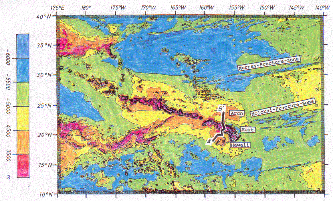
Fig.1. Bathymetry of the Hawaiian swell. The isoline interval is 500m. The 5000 m water depth isoline (fat) outlines the Hawaiian swell best. MIN refers to deeper waters, MAX to shallower waters. Note the Molokai and the Murray Fracture Zones as well as the deeper waters close to the islands (moat) and the shallower waters in the distance (arch) to the island chain of Hawaii. The data are from the ETOP-5 data set of the Geophysical Data Center in Boulder, Colorado, USA. Note, the profile A'B' which has been considered in more details in Figs. 3 and 4.
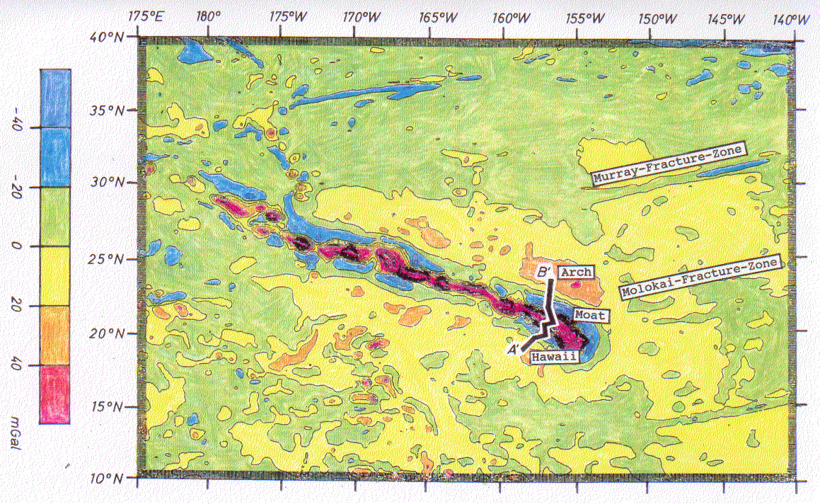
Fig. 2. Free-air anomaly data of the Hawaiian swell deduced from SEASAT- data. The isoline interval is 20mGal. The 0 - line (fat) outlines the approximate dimensions of the regional Hawaiian swell quite well. Additionally, it outlines gravity minima in the moat areas around the islands. Local minima are marked by MIN, local maxima by MAX. Note, the profile A'B' which has been considered by gravity modelling in Figs. 3 and 4.
Similar to the broad topographic swell the free-air gravity field as depicted in Fig. 2 shows a regional high around the Hawaiian islands. This high is almost identical to the topographic extension of the swell. Bathymetric as well as gravity data show the minimum close to the islands that is superimposed the regional trend. In contrast to the bathymetry the gravity data do show a strong low also in front of Big Island.
PREVIOUS MODELS DERIVED MAINLY FROM SEISMIC STUDIES
Geophysical investigations of the crustal structure underneath Hawaii have been started by gravity studies of Vening Meinesz (1941) and Woollard (1951). The structure of the volcanic interior and the surrounding oceanic crust has been concluded from refraction seismological measurements (Hill, 1969; Zucca and Hill, 1980; Zucca et al., 1982; Hill and Zucca, 1987). These authors found the Moho in a depth of 18.5 km underneath Mauna Loa and in a depth of 16 km underneath Kilauea. All seismic and density models presented so far show a thickened crust below the islands, but might be wrong due to incomplete knowledge of the density and velocity distribution within the crust. Ellsworth and Koyanagi (1977) derived a model that shows the three-dimensional velocity distribution down to a depth of 65 km below Hawaii. The Moho is characterized by a velocity difference of 0.9 km/s and a density contrast of 0.4 g/cm3 (Lindwall, 1988). The deeper crustal structure has been concluded from flexure theory by Watts et al. (1985).
In 1982 the Lamont-Doherty Geological Observatory and the Hawaii Institute of Geophysics have started the seismic Hawaii-experiment campaign near Oahu. The seismic data have been acquired along a 600 km long and a 100 km wide profile net perpendicular to the strike direction of the Hawaiian island chain (Watts et al., 1985). These campaign has been carried out in order to find constraints for developing a model that explains the flexure of the oceanic crust due to the volcanic load. Refraction data obtained have been used to define seismic velocities, seismic reflection data have been used to identify sedimental layering and crustal reflections.
Watts et al. (1985), ten Brink and Brocher (1987) and Lindwall (1988) built two-dimensional density models that are mainly constrained by reflection and refraction seismology and free-air gravity. In this paper, these models have been recalculated in order to understand the effects of the single bodies involved. The conversion of seismic velocities into densities in Watts et al. (1985), ten Brink and Brocher (1987) and Lindwall (1988) is based on the curves of Christensen and Salisbury (1975) and Manghani and Woollard (1968). The newly calculated versions of the models built by Watts et al. (1985) and ten Brink and Brocher (1987) are depicted in Fig. 3, the model of Lindwall (1988) in Fig. 4. The models of Fig. 3 and Fig. 4 differ in the existence of a subcrustal body underneath the islands.
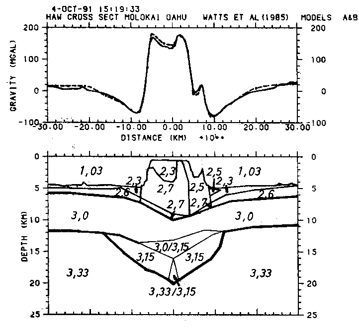
Fig. 3. Two-dimensional crustal model of the Hawaiian chain after ten Brink and Brocher (1987) and Watts et al. (1985). The dashed line indicates the measured free-air gravity anomaly. The model consists actually of two alternative versions, model A and B that both yield the calculated gravity curve. The models A and B differ in their identification of the subcrustal intrusive complex. Model A assumes a normal crust with an underlying intrusive body. Model B assumes a thinned crust that is compensated by a volcanic plug of denser material within the subcrustal body. All densities are in g/cm3. The geographical location of the profile considered is shown in Figs. 1 and 2.
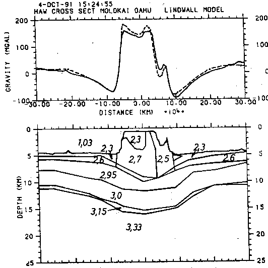
Fig. 4. Interpretation of the same data used in Fig. 3 after Lindwall (1988) who does not see the subcrustal structures. This model shows that gravity modelling also yields the measured data by assuming a simple structured and flexured crust. Gravity modelling does not resolve the existence of a subcrustal body. Thus, it is sufficient to assume a simply flexured crust when developing the regionally extended three-dimensional model.
In relation of rifting processes Meissner and Koepnick (1988) have identified bodies at the basis of the crust underneath anomalous plateaus and structures at Atlantic margins that are characterized by high p-velocities (7.2 - 7.8 km/s). Areas of low viscosity as underneath the continental crust prior to rifting promote a large lateral extension of upwelling material. As a consequence magmatic material intrudes into the lower continental crust after Meissner and Koepnick (1988) during the initial phase of rifting. This material then results in subcrustal intrusive bodies. These bodies are very similar to the one predicted by Watts et al. (1985) underneath the Hawaiian islands.
Fig. 3 distinguishes between model A and model B. Model A assumes a normal crust with an underlying intrusive body. In model B the subcrustal body is smaller. The oceanic crust is not thinned out as shown in model A. For compensation in model B a high density body, the volcanic plug, is introduced into the subcrustal body. Lindwall (1988) has shown that the seismic data also are consistent with free-air gravity data without the subcrustal intrusive body at all. The differentiated crustal structure also matches the seismic and gravity data available. Thus, it cannot be distinguished between the existence of the subcrustal body or the existence of simple flexured crust.
The models depicted in Figs. 3 and 4 are only two-dimensional and cover only a very local area of the huge Hawaiian hot spot system. This system is outlined by the regional swell structure that surrounds the Hawaiian archipelago. Only the crustal structure of the islands itself has been considered so far. But no attempt has been made so far to give a density model that tries to reproduce the measured gravity field and includes the plume structure that is widely accepted as the Hawaiian origin in the deep.
SWELL ORIGINS
Unfortunately, the Hawaii experiment (Watts et al., 1985) did not consider the hot spot system of Hawaii beyond the scope of the crustal flexuring due to the volcanic load. Questions about the reason for the occurrence of this volcanism have not been discussed in that context. In this paper, it is asked for origins for the above modelled processes that are located beneath the model depth of the crustal sections, i.e. in the lower lithosphere and in sublithospheric depths. Is the swell simply the consequence of lithospheric flexure due to the volcanic load, is it due to a sublithospheric plume structure, is it simply due to gravity equilibrium of huge density deficiencies in the lithosphere or is it a complex combination of all of that?
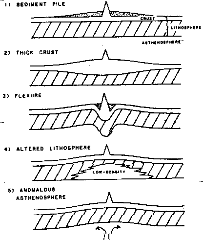
Fig. 5.
Support mechanisms for hot spot swells redrawn from Crough
(1983).
a) sediment pile
b) thickened crust
c) flexure
d) altered lithosphere of reduced density
e) anomalous asthenosphere (plume)
Models a) and b) are contradicted by seismic results which are
modelled in Figs. 3 and 4. Models a), b) and c) are shallow
support mechanisms, models d) and e) deep support mechanisms.
This paper suggests not to see the models independently, but a
combined support of models c) d) and e). A causal relationship
between models c), d) and e) where model e) is considered as the
original support and models d) and c) are resulting interactions
with the lithosphere and the crust/surface seems to be a
suitable approach to be treated.
Crough (1983) reviewed possible support mechanisms (see Fig. 5) of hot spot swells. The flexure model c) is included in the two-dimensional models of Figs. 3 and 4. This model explains shape and width of the regional swell. However, it does not explain the observed height and free-air gravity anomaly of the swell (Crough, 1983). The results depicted in Figs. 3 and contradict the sediment pile model a) and the thickened crust model b). The models a), b), and c) try to explain the swell by crustal and thus shallow origins. The models d) and e) refer to a possible deep seated origin for the swell.
The plume as a possible swell origin is identified with model e). The plume is the sublithospheric body that encounters the base of the lithosphere as depicted by model e). The model calculations by Watts et al. (1985) and Lindwall (1988) explain the structure and the flexure of the crust. However, this does not account for the origin of the hot spot. Thus, a scenario has to be modelled that includes the flexure as a consequence of another process. Isostatic adjustment on continents takes place within thousands of years after Walcott (1970b). For there is no reason why this should be longer in oceanic crust environment volcanic edifices should be compensated soon (within thousands of years) after their formation. After Walcott (1970a) the volcanic mass results in a flexure of the lithosphere as depicted in Fig. 5c). Furthermore, a spatial connection between the observed volcanism on the one hand and the plume structure as the responsible hot spot origin on the other hand is necessary. It is tried to model the following process:
In the beginning there is updoming of the lithosphere due to the plume reaching the base of the lithosphere (model e) of Fig. 5). The plume then interacts with the lithosphere and produces areas of "altered" lithosphere as shown in model d) of Fig. 5. As one consequence of this plume lithosphere interaction volcanism can be observed. The produced volcanic load then results in a flexure of the crust after model c) in Fig. 5. Thus, in the present state the Hawaiian hot spot system seems to be a causal relationship of the models c), d) and e) in Fig. 5.
MANTLE PLUMES
Mantle plumes have never been observed so far. They exist in the brains of geoscientists as an explanation of huge volcanic edifices far away from any plate boundary. There is only indirect evidence for the existence of mantle plumes so far. Progressively aged island chains and regional swells are considered as possible reactions of crust and lithosphere to sublithospheric plume activities. Additionally, seismic tomography yields further evidence that there are possible plume-like structures (Anderson et al., 1992).
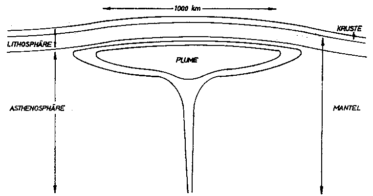
Fig. 6. Geometric shape of a typical mantle plume structure. Note the narrow pipe supporting the plume and the mushroom-shaped extension at the lithospheric base.
Fig. 6 shows the size and the shape of a typical plume structure after Courtney and White (1986). Seismic tomography shows regions of reduced seismic velocity especially in sublithospheric depths of 100 - 200 km due to higher temperatures relative to undisturbed mantle material. Numerous papers have been published on the nature of plumes. There are experimental results that try to give an empirical idea of plume dynamics (e.g. Olson and Nam, 1986; Whitehead and Luther, 1975) and theoretical calculations of geodymical processes (e.g. Ribe and Christensen, 1994; Li Yinting and Spohn, 1991). This paper has to be considered as another contribution giving more arguments in favour the existence of such a plume structure.
In order to check the evidence of the existence of a mantle plume with gravity modelling appropriate information of the density of the plume structure is needed. It is not important to use an absolute value. The gravity signal of a plume structure is given by the relative density contrast between plume and surrounding asthenospheric material.
Assuming a mantle viscosity of 10 22 Poise Richards et al. (1989) yielded the very high value of ** = - 0.1 g/cm3 for the mantle plume density contrast to the surrounding material. This value was deduced from thermal considerations after Richards et al. (1988) who used an average mantle density of *0 = 5.14 g/cm3 and a temperature contrast of *T = 800 K. The thermal density contrast to surrounding material is given by
** = - *0 * * T (1)
where *0 is the mean mantle density * T is the temperature contrast between mantle plume and surrounding material * is the thermal expansion coefficient 3 . 10 -5/K.
Sleep et al. (1988) and Sleep (1990) mention a density contrast of -0.03 g/cm3. This value yields after equation (1) an equivalent temperature difference of 300 K with an assumed upper mantle density of 3.3 g/cm3. Sleep (1990) mentions that the average upper mantle density can be calculated with the value of *T = 200 K. This would result in a density contrast of ** = -0.02 g/cm3.
Li and Spohn (1991) calculated density values for mantle plumes after the formula
* = *s (1- *) + *l *
where *s = 3.3 g/cm3 is the matrix density (mantle density) * is the per cent of melt ("porosity") *l = 2.8 g/cm3 is the density of the molten part and * is the mantle plume density.
The density contrast the mantle plume has to be modelled with then is * * = * - *s.
A porosity of 0.05 yields **= -0.025 g/cm3. A mantle plume structure can be described by a uniform density value of -0.02 g/cm3 as the reduced density contrast for the mantle plume yielded by the above discussed density contemplations.
There are numerous factors that influence the mantle plume structure's gravity signal on the surface: size, depth, density contrast, internal density gradients and so on. A cylindrical mantle plume with almost 1000 km in diameter and a thickness that is around 100 km in its center and is gradually reduced to the outer parts has been modelled (Schmidt, 1994). Structures of this dimension always yield a regional circular gravity anomaly that slightly exceeds the diameter of the plume and an amplitude of more or less 60 mgals. This result means, that any mantle plume structure of similar size should be possible to be identified in the regional gravity field around a potential hot spot.
PROCESSING AND DEFINING THE REGIONAL BOUGUER GRAVITY FIELD
The three-dimensional gravity modelling applied in this work is based on the algorithms of Goetze and Lahmeyer (1988). In order to keep calculation time limited the data shown in Fig. 2 have been reduced from approximately 144000 data points to around 1000 data points. For the interest was focussed on the regional gravity field a simple reduction of the data points (instead of a sample distance of 5 minutes only values at full degrees have been accepted) without any additional mathematical operations was sufficient. Schmidt (1994) used synthetic data that consisted of a regional swell and local seamounts in order to test the above mentioned data reduction and in order to define the degree of Chebychev polynomials that outlines the regional field best. The complete Bouguer gravity field has been calculated by replacing the water by crustal material. The regional Bouguer gravity field then has been obtained by applying Chebychev polynomials of degree 9 to the result. The obtained regional Bouguer gravity field has been used as "measured", i. e. reference gravity in the process of model construction. The model gravity field had to fit this field that is shown in Fig. 7 as best as possible.
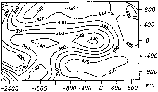
Fig. 7. The regional Bouguer gravity map. Interval of isolines is 20 mGal. The swell axis is x=0. Big Island is located at (0,0). The model has been defined perpendicular to the strike direction of the Hawaiian Island chain and its elongated swell structure. The used reduction density for the water body has been 1.95 g/cm3 which is the difference between water density and an assumed medium crustal density.
MODEL DEVELOPMENT
The gravity signal of a plume with cylindrical shape cannot account for the whole gravity low obtained along the swell (Fig. 7). This elongated gravity low indicates huge mass deficiencies also well downstream the swell. Detailed model calculations in Schmidt (1994) have shown that a distorted plume structure due to the Pacific plate movement alone also cannot account for the excentric regional low at all.
The discussion of possible swell origins yielded a possible hot spot scenario that explained the volcanism due to a mantle plume interacting with the lithosphere in general. The presumed mantle plume existence is concluded from the morphologic and geologic observations on the surface (island chains, ocean island basalts). The proof of the existence of mantle plumes has not been presented so far. However, seismic tomography has recently been interpreted to reveal seismic velocity lows in sublithospheric depths around 130 km (Anderson et al., 1992; Zhang and Tanimoto, 1992; Schmidt, 1994). These depths do account for mantle plumes.
The origin of the volcanism observable at the surface is assumed to be the presence of a plume that is located beneath the lithosphere. Thus, the plume signal has succesfully penetrated the lithosphere. This means, that a plume interaction with the lithosphere (heat penetration mechanisms) must have taken place. Continuing heat transfer from the sublithospheric distorted plume after the initial penetration of the lithosphere documented by volcanism suggests the existence of a regionally altered lithosphere. The existence of such an altered lithosphere beneath a hot spot has been suggested by Crough (1981) for the Hoggar hot spot. Thus, a complete mantle plume hot spot system can be modelled as a superposition of the effects depicted in Figs. 5 c),d) and e).
Due to relative movements between asthenosphere and lithosphere volcanism occurs at the front of the tilted plume as it is the case with the Hawaiian active volcanism. The thickness of the altered lithosphere increases to the westnorthwest as long as there is plume material present in the sublithosphere exchanging heat with the lithosphere. The increase of an area of altered lithosphere to the westnorthwest is also supported by a thermal model after Sleep (1987). His model suggests lithospheric heating westnorthwest of the island of Hawaii. Heat flow measurements that have been reported by von Herzen et al. (1982, 1989) moreover do support this hypothesis. However, von Herzen et al. (1989) doubt the values listed in von Herzen et al. (1982). But they conclude, if there is any significant heat flow anomaly then it is at its maximum amplitude around the intersection of the Hawaiian track with the Murray fracture zone. This means a location far downstream the current hot spot location. The model has to account for a broad heating of the lithosphere after it has already passed the most active plume center due to further interaction processes with the distorted plume. Thus the process of lithospheric alteration does not stop by the absence of recent volcanism in the downstream part of the elongated swell.
The long-time lithospheric interaction may be explained by assuming conduction as the dominating heat transfer process within the lithosphere. Volcanism is a short-time process due to active transport of material. Convection can be considered the principal heat transfer mechanism within the asthenosphere. Due to the rapid movement of the Pacific plate the areas of short- time (convective) and long-time (conductive) regional lithospheric plume interaction are spatially separated.
The subcrustal body discussed by Watts et al. (1985) and ten Brink and Brocher (1987) cannot be resolved by the regional gravity field. Furthermore after the results of Lindwall (1988) it cannot be distinguished from the gravity signal of a simple flexured multilayered crust. Therefore the model presented in this paper does include only a simple crust mantle boundary that follows the results of Watts and ten Brink (1989) around the hot spot center and decreases in its amplitude downstream due to the erosion and subsidence of the volcanic load.
The shape of the plume body can be described by the stagnation stream line after Sleep (1987) and Olson (1990). This line defines the surface that is characterized by the contact between plume and asthenospheric material.
After the distorted plume has died out further downstream the heat transfer from plume into the lithosphere is finished. Thus, no further heating of the lithosphere can take place. Thus, the thickness of the altered lithosphere starts to decrease and cooling processes begin to dominate the originally plume affected region. In the end, the only observable signature at the surface will be subsided and eroded islands. This is the present state of the Emperor chain.
THE MODEL STRUCTURE
Schmidt (1994, 1996) developed a three-dimensional density structure that is able to explain the shape and the size of the regional Hawaiian Bouguer gravity signal. The detailed structure is shown in a perspective view in Fig. 8.
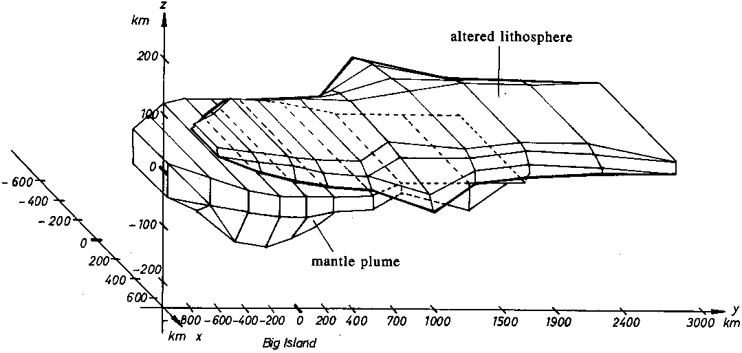
Fig. 8. Three-dimensional perspective view of the model consisting of the computed shape of the altered lithosphere and the supporting plume. The crust-mantle boundary is not shown for simplicity. Its shape is deduced from the results of Figs. 3 and 4 within the active part of the islands. To the limits of the model in all directions it gradually reaches a uniform depth of 12 km. The bathymetry has already been put into the calculation of the regional Bouguer gravity field. The plume head reaches a minimum depth of 70 - 80 km. The altered lithosphere's maximum thickness is 50 km downstream from the plume rise center. The maximum width of the altered lithosphere indicates a possible interaction with the Murray Fracture Zone.
The bodies that define the exact 3D-model are characterized by a constant density value. The model derived here does not consider the continuous density gradient with depth but bodies that disturb the assumed density layering. Thus it is sufficient to model the relative density contrast of the bodies to their surroundings in the same depth. In the upper part of the plume there is a lower density than in the lower parts (Li and Spohn, 1991). For the buoyancy mechanism is driven by density contrasts the plume is modelled by a constant density contrast of -0,02 g/cm3 with respect to its surroundings.
By using numerous models of bodies with a large number of varying densities it is quite easy to reproduce a measured gravity field. In this paper, the main purpose is to find out whether it is possible, to reproduce the regional Bouguer gravity field as good as possible by as few as possible used structures with their relative densities with respect to their surroundings. The used density contrasts were attributed to the crust mantle boundary, the altered lithosphere and the sublithospheric plume structure.
The density values used are
* * = -0.24 g/cm3 for the crust mantle boundary, * * = -0.03 g/cm3 for the altered lithosphere, * * = -0.02 g/cm3 for the mantle plume.
The thickness of the plume head of the calculated model is in its central part 100 km, the depth of the plume encountering the base of the lithosphere is assumed to be 70-80 km. The thickness of the altered lithosphere is defined from the plume center of upwelling material downstream the swell. It reaches its maximum thickness of roughly 50 km at 1800 km downstream the swell from the hot spot center (see also Fig. 10).
The relative density of the plume has been derived from the considerations of Li and Spohn (1991). The calculations base upon a mantle density of 3.3 g/cm3 and an excess temperature of the plume of 200 K. The relative density of the crust mantle boundary of 0.24 g/cm3 bases upon values from Toksoez (1985). A density of 3.24 g/cm3 for the upper lithospheric layer and a density value of 3.0 g/cm3 for the lower crustal layer has been assumed. The density value of the altered lithosphere is empirical. It is mainly derived from optimizing the model densities to represent the regional gravity field without introducing further model structures. Numerous authors have contemplated on interaction processes of plumes and lithosphere (e. g. Ribe and Christensen, 1994; Saunders et al., 1992). But none of them has given a unique density contrast value that could be used for gravity modelling. The primordial geochemical signal of volcanics of hot spot locations refer to a transport of this material through the whole lithosphere. After Glahn et al. (1992) and Hoernle et al. (1991) this cannot be done without interaction with the lithosphere. There must be some kind of reducing the lithospheric density by chemical and/or thermal processes.
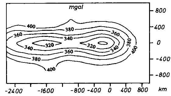
Fig. 9.
a) gravity field of the calculated three-dimensional model.
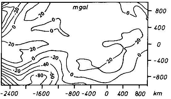
Fig. 9.
b) differences of regional Bouguer gravity and model gravity.
Positive values indicate a value of the Bouguer gravity that is
larger than the one yielded by the model.
The three-dimensional shape of the model in the computer (Fig. 8) yields approximately the regional Bouguer gravity field (Fig. 7). Fig. 9 a) shows the model gravity field and Fig. 9 b) depicts the differences between the model gravity and the field of Fig. 7.
No attempt has been made to model the disturbances in the southwest of the area of the gravity field (Figs. 7 and 9 b)). Here, other processes independent of the contemplated Hawaiian hot spot system do produce these anomalies. Therefore they have not been included into this model in order to keep control of the modelled processes here. The contribution of the Hawaiian hot spot system to regional gravity independent of surrounding processes has been consiedered only. A possible interaction with the Murray Fracture Zone downstream the swell is indicated in the model by a local thickening of the plume head and widening of the altered lithosphere body.
CONCLUSIONS
The constructed three-dimensional model represents the present geological state which is illustrated in Fig. 10 by two cartoons. The origin of the Hawaiian swell and thus, the processes going on beneath the Hawaiian hot spot system, can be explained by interpreting the calculated model as follows.
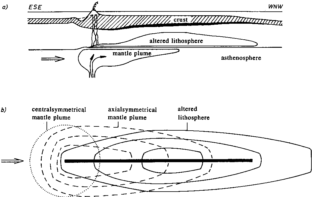
Fig. 10.
Cartoon of the three-dimensional model structure.
a) profile view along the swell axis illustrating the geophysical process,
b) transparent bird's eye view.
a) Directly above the upstreaming material of the plume there is
volcanism, while the plume itself becomes distorted due to the
Pacific plate velocity. An altered lithosphere is created as a
consequence of a plume lithosphere interaction process.
b) The shape of an undisturbed plume (dotted line) and the shape
of the modelled plume structure (dashed lines) is compared. The
body shape of the altered lithosphere is depicted as solid
lines. Due to the relative movement of lithosphere and
asthenosphere the maximum thickness of altered lithosphere
occurs downstream the hot spot center. The three lines indicate
differences in the thickness of the structures. The inner part
is the thickest part.
Mantle plume material rises in the asthenosphere. This material reaches the base of the lithosphere and spreads there to various directions. Due to the velocity of the Pacific plate it is distorted downstream (see Fig. 10). Above the upstreaming center of the mantle plume a short lived plume lithosphere interaction results in volcanism due to fractioning of lithosphere and crust and additional melt generation. The volcanic load flexures the crust. The on-going influence of the mantle plume interaction on the lithosphere results in a long-time change of the physical and chemical properties of the lithosphere. An altered lithosphere will be generated. This regional plume lithosphere interaction occurs at all parts of the lithosphere that are underlain by sublithospheric plume material that releases heat into the lithosphere. Due to the movement of the Pacific plate the maximum effect of this regional plume lithosphere interaction that bases upon heat conduction does occur downstream from the hot spot center. The influence of the plume diminishes with distance from the hot spot center. The altered lithosphere production decreases from that moment on when the plume material is not any more present at the lithospheric base. After all of the hot spot activity has been ceased only tracks of eroding volcanoes can be observed.
Assuming a plume head thickness of 125 km where the plume itself has a relative density of -0.02 g/cm3 with respect to its surroundings the product of these values yields 2.5 km g/cm3. The same value is obtained by multiplying the density difference of 1.67 g/cm3 (this is the mean density of the upper crust reduced by the density of the water) with 1.5 km (average height of the topographic swell anomaly). This means that the excess mass produced by the topographic swell is compensated by the deficient mass of the plume volume. Further downstream the plume gets replaced by the altered lithosphere. This simple consideration shows that the model should by isostatically compensated in a regional scale.
Finally, the following conclusions, that characterize the present state of the Hawaiian hot spot system modelled by the three-dimensional structure presented in this paper can be given:
1. Further evidence for the existence of a mantle plume beneath Hawaii has been found. Its contribution to gravity is not negligible and therefore can be seen in the observations. The proposed model explains the gravity field.
2. The mantle plume beneath the Hawaiian hot spot has been tilted due to the superposition of the plume rise with the westnorthwestern direction of the Pacific plate velocity. The shape of the plume can be described by the stagnation streamline (Sleep, 1990). Upstream the plume is extremely shortened. Downstream the plume is lengthened and gets gradually smaller in thickness and width. The streaming itself can be active in the asthenosphere or passive in the lithosphere due to the plate drift (slab-pull and ridge-push effects (after Fowler, 1990).
3. The volcanism above the plume center reveals that there is a very small connection between plume and surface that is used for material transport. The concentration of volcanism above the plume center is also explained by Li and Spohn (1991) due to the curvature in the flow of the material transport there. The upstreaming direction changes into horizontal directions along the lithospheric base. The lithosphere is penetrated within a very short time scale. This is called the short-time plume lithosphere interaction. The melt can be produced actively due to the plume and passively due to remobilization of pre-existing disturbances in the lithosphere that lead to a decompression and therefore melting. For both cases the source of material is the same and therefore the geochemical signal, too (namely from the base of the lithosphere).
4. The anomaly downstream (minimum) of the regional Bouguer-gravity field can be explained by various origins that are represented by the model. There is still old or again renewed anomalous asthenosphere. Thus the modelled plume structure is thickened there again due to the following possible processes: a) After Whitehead (1982), Olson and Singer (1985) and Olson and Nam (1986) a plume falls to pieces if it is tilted more than 30 degrees. The resulting "blobs" of the plume will produce a hot spot activity that is in geological time scale sometimes much more and sometimes much less active. Thus, downstream relicts of a former blob impact (increased amount of plume material having arrived) at the lithospheric base are observed. The current activity around Hawaii is the next larger plume material impact. b) Because of the geographical location at the intersection of the Hawaiian island chain with the Murray-Fracture-Zone (Wessel, 1993) a lithosphere plume interaction could have taken place: The weakened lithosphere may force decompression and renewing the reduction of the density and thus melt production. c) A superposition of two or more of the mentioned processes is also possible.
5. The regional Bouguer gravity field downstream the swell cannot be explained by the plume alone. Here, the regional plume lithosphere interaction has been modelled. Because of the Pacific plate velocity this interaction does not take place directly above the upstreaming center of the plume but well downstream due to the on-going heat release from the plume.
The results concluded from the model are valid in their details only for the Hawaiian hot spot. However, it can be concluded several consequences for other hot spot locations. It is shown that there is a regional plume lithosphere interaction. This process depends largely on the relative plate velocity. Hawaii is characterized by a fast moving plate environment. This results in the spatial separation of the short-time plume lithosphere interaction (material transport with consequent volcanism) and the long-time interaction (conductive heat release into the lithosphere of the asthenospheric plume). Thus, Hawaii is dominated by an excentric or tilted plume lithosphere interaction. Such a tilted plume lithosphere interaction has recently also been reported by Morgan et al. (1995).
In the case of a slow moving plate as the African plate a spatial separation of processes should not be expected. This situation can be studied at the Cape Verde or the Canary hot spot systems. In the contrary to Hawaii where the plate velocity may be responsible for the absence of the significant heat flow anomaly (von Herzen et al., 1989) the Cape Verde hot spot does show the expected heat flow anomaly (Courtney and White, 1986). Thus, due to a slow moving plate the short- and long-time plume lithosphere interaction is not spatially separated. Here, in the contrary to Hawaii, volcanism can be found wide-spread above the regional extension of the plume. The Canary islands of Lanzarote, Teneriffa and La Palma show old and young volcanism in one edifice inferring a long-time persistence of the plume interaction beneath the same geographical hot spot location.
The volcanic activity of Hawaii is despite the location on the fast moving Pacific plate obviously stronger than the volcanism on the Canary islands which are located on a slow moving plate. The Hawaiian volcanism would be even stronger if Hawaii would have been located on a slow moving plate. Therefore it is concluded that a mantle plume as strong as beneath Hawaii interacting with a slow moving plate would initiate a possible rifting process to release all the heat of the plume.
ACKNOWLEDGMENTS
This paper has been part of the PhD-thesis of the author. I wish to thank particularily Prof. Dr. P. Janle for many useful discussions on the nature of Hawaii and comparable hot spot locations on other terrestrial planets. This work additionally benefited from geodynamical discussions on the structure and evolution of plumes with Prof. Li Yinting and general discussions with Prof. R. Meissner. The author thanks Prof. H.- J. Goetze from the Free University of Berlin for providing his 3D-gravity modelling program package IGAS. Moreover, I thank Dr. Sabine Schmidt for calculating the Bouguer gravity field of the Hawaiian swell region. The manuscript has been further improved by discussions with Dr. J. Fritsch.
REFERENCES
Anderson, D. L., Zhang, Y. S., and Tanimoto, T., 1992, Plume heads, continental lithosphere, flood basalts and tomography, in: Magmatism and the causes of continental break-up, ed. by B. C. Storey, T. Alabaster and R. J. Pankhurst, Geol. Soc. Spec. Publ., 68, p. 99-124.
Christensen, N. I., and Salisbury, M. H., 1975, Structure and constitution of the lower oceanic crust, Rev. Geophys., 13, p. 57-86.
Courtney, R. C., and White, R. S., 1986, Anomalous heat flow and geoid across the Cape Verde Rise: evidence for dynamic support from a thermal plume in the mantle, Geophys. J. R. Astron. Soc., 87, p. 815-868.
Crough, S. T., 1981, Free-air gravity over the Hoggar massif, northwest Africa: evidence for alteration of the lithosphere, Tectonophysics, 77, p. 189-202.
Crough, S. T., 1983, Hotspot swells, Ann. Rev. Earth Planet. Sci., 11, p. 165-193.
Duncan, R. A., and Richards, M. A., 1991, Hotspots, mantle plumes, flood basalts and true polar wander, Rev. Geophys., 29, p. 31-50.
Ellsworth, W. L., and Koyanagi, R. Y., 1977, Three-dimensional crust and mantle structure of Kilauea volcano, Hawaii, J. Geophys. Res., 82, p. 5379-5394.
Fowler, C. M. R., 1990, The solid Earth: an introduction to global geophysics; Cambridge University Press, Cambridge.
Glahn, A., Sachs, P. M., and Achauer, U., 1992, A teleseismic and petrological study of the crust and upper mantle beneath the geothermal anomaly Urach/SW-Germany, Phys. Earth Planet. Int., 69, p. 176-206.
Goetze, H.-J., and Lahmeyer, B., 1988, Application of three- dimensional interactive modeling in gravity and magnetics, Geophysics, 53, p. 1096-1108.
Hill, D. P., 1969, Crustal structure of the island of Hawaii from seismic refraction measurements, Bull. Seismol., Soc. Am., 59, p. 101-130.
Hill, D. P., and Zucca, J. J., 1987, Constraints on the structure of Kilauea and Mauna Loa volcanoes, Hawaii, and some implications for seismo-magmatic processes, U. S. Geol. Surv. Prof. Pap., 1350, p. 903-917.
Hoernle, K., Tilton, G., and Schmincke, H.-U., 1991, Sr-Nd-Pb isotopic evolution of Gran Canaria: evidence for shallow enriched mantle beneath the Canary islands, Earth Planet. Sci. Lett., 106, p. 44-63.
Li Yinting and Spohn, T., 1991, Vertical structure of the head of a cylindrical mantle plume from a model of two-phase flow with melting, Geophys. J. Int., 107, p. 103-115.
Lindwall, D. A., 1988, A two-dimensional seismic investigation of crustal structure under the Hawaiian islands near Oahu and Kauai, J. Geophys. Res., 93, p. 12107-12122.
Manghani, M. H., and Woollard, G. P., 1968, Elastic wave velocities in Hawaiian rocks at pressures to ten kilometers, in: The crust and the upper mantle of the Pacific area, Geophys. Monogr. Ser., 12, ed. by L. Knopoff, C. L. Drake and P. J. Hart, p. 501-516, AGU, Washington, DC.
Meissner, R., and Koepnick, M., 1988, Structure and the evolution of passive margins: the plume model again, J. Geodynamics, 9, p. 1-13.
Morgan, W. J., 1971, Convection plumes in the lower mantle, Nature, 230, p. 42-43.
Morgan, W. J., 1972, Deep mantle convection plumes and plate motions, Am. Assoc. Pet. Geol. Bull., 56, p. 203-213.
Morgan, J. P., Morgan, W.J., and Price, E., 1995, Hotspot melting generates both hotspot volcanism and a hotspot swell?, J. Geophys. Res., Vol. 100, No., B5, p. 8045-8062.
Olson, P., 1990, Hot spots, swells and mantle plumes, in: Magma transport and storage, ed. by M. P. Ryan, J. Wiley, p. 33-54.
Olson, P., and Singer, H., 1985, Creeping plumes, J. Fluid Mech., 158, p. 511-531.
Olson, P., and Nam, I. S., 1986, Formation of seafloor swells by mantle plumes, J. Geophys. Res., 91, p. 7181-7191.
Ribe, N. M., and Christensen, U. R., 1994, Three-dimensional modelling of plume-lithosphere interaction, J. Geophys. Res., 99, B1, p. 669-682.
Richards, M. A., Hager, B. H., and Sleep, N. H., 1988, Dynamically supported geoid highs over hotspots: observation and theory, J. Geophys. Res., 93, B7, p. 7690-7708.
Richards, M. A., Duncan, R. A., and Courtillot, V. E., 1989, Flood basalts and hot-spot tracks: plume heads and tails, Science, 246, p. 103-107.
Saunders, A. D., Storey, R., Kent, R. W., and Norry, M. J., 1992, Consequences of plume lithosphere interactions, in: Magmatism and the causes of continental break-up, ed. by B. C. Storey, T. Alabaster and R. J. Pankhurst, Geol. Soc. Spec. Publ., 68, p. 41-60.
Schmidt, P., 1994, Klassifizierung der Hot Spots und die Dichtestruktur des Hawaiianischen Mantel-Plume-Hot-Spots (in German), PhD-thesis, Christian-Albrechts-University, Kiel, Germany.
Schmidt, P., 1996, Tilted plume lithosphere interaction underneath Hawaii, EGS XXIth General Assembly, Den Haag (Abstract).
Sleep, N. H., 1987, An analytic model for a mantle plume fed by a boundary layer, Geophys. J. R. Astron. Soc., 90, p. 119-128.
Sleep, N. H., 1990, Hotspots and mantle plumes: some phenomenology, J. Geophys. Res., 95, B 5, p. 6715-6736.
Sleep, N. H., Richards, M. A., and Hager, B. H., 1988, Onset of mantle plumes in the presence of preexisting convection, J. Geophys. Res., 93, B 7, p. 7672-7689.
ten Brink, U. S., and Brocher, T. M., 1987, Multichannel seismic evidence for a crustal intrusive complex under Oahu and a model for Hawaiian volcanism, J. Geophys. Res., 92, B 13, p. 13687- 13707.
Toksoez, M. N., 1985, The subduction of the lithosphere (in German), in: Ozeane and Kontinente, Spektrum-der-Wissenschafts- Verlagsgesellschaft, Heidelberg, p. 106-116.
Vening Meinesz, F. A., 1941, Gravity over the Hawaiian archipelago and over the Madeira area; conclusion about the Earth's crust, Prock. Ned. Akad. Wet., 44, p. 2-12.
von Herzen, R. P., Detrick, R. S., Crough, S. T., Epp, D., and Fehn, U., 1982, Thermal origin of the Hawaiian swell: heat flow evidence and thermal models, J. Geophys. Res., 87, p. 6711-6723.
von Herzen, R. P., Cordery, M. J., Detrick, R. S., and Fang, Changle, 1989, Heat flow and the thermal origin of hot spot swells; the Hawaiian swell revisited, J. Geophys. Res., 94, B 10, p. 13783-13799.
Walcott, R. I., 1970a, Flexural rigidity, thickness, and viscosity of the lithosphere, J. Geophys. Res., 75, p. 3941- 3954.
Walcott, R. I., 1970b, Flexure of the lithosphere at Hawaii, Tectonophysics, 9, p. 435-446.
Watson, S., and McKenzie, D., 1991, Melt generation by plumes: a study of Hawaiian volcanism, J. Petrol., 32, p. 501-537.
Watts, A. B., and ten Brink, U. S., 1989, Crustal structure, flexure, and subsidence history of the Hawaiian islands, J. Geophys. Res., 94, B8, p. 10473-10500.
Watts, A. B., ten Brink, U. S., Buhl, P., and Brocher, T. M., 1985, A multichannel seismic study of lithospheric flexure across the Hawaiian-Emperor seamount chain, Nature, 315, p. 105- 111.
Wessel, P., 1993, Observational constraints on models of the Hawaiian hot spot swell, J. Geophys. Res., 98, B 9, p. 16095- 16104.
Whitehead, J. A., 1982, Instabilitites of fluid conduits in a flowing Warth - Are plates lubricated by the asthenosphere,?, Geophys. J. R. Astron. Soc., 70, p. 415-433.
Whitehead, J. A., and Luther, D. S., 1975, Dynamics of laboratory diapir and plume models, J. Geophys. Res., 80, p. 705-717.
Wilson, J. T., 1963a, Evidence from islands on the spreading of ocean floors, Nature, 197, p. 536-538.
Wilson, J. T., 1963b, A possible origin of the Hawaiian islands, Can. J. Phys., 41, p. 863-870.
Woollard, G. P., 1951, A gravity reconnaissance of the island of Oahu, EOS Trans. AGU, 62, p. 358-368.
Zhang, Y. S., and Tanimoto, T., 1992, Ridges, hotspots and their interaction as observed in seismic velocity maps, Nature, 335, p. 435-439.
Zucca, J. J., and Hill, D. P., 1980, Crustal structure of the southeast flank of Kilauea volcano, Hawaii, from seismic refraction measurements, Bull. Seismol. Soc. Am., 70, p. 1149- 1159.
Zucca, J. J., Hill, D. P., and Kovach, R. L., 1982, Crustal structure of Mauna Loa volcano, Hawaii, from seismic refraction and gravity data, Bull. Seismol. Soc. Am., 72, p. 1535-1550.
zur BegrüßungsseiteYou are counted visitor ![]() since 29th Dec 1998!
since 29th Dec 1998!